Clay Masterson, Backcountry Conditioning Expert & Gear Pragmatist
July 24, 2026 · 14 min read
Permit lottery fatigue is driving hikers to regional trails
Permit systems were supposed to manage impact. Fair enough. A fragile basin, a narrow corridor, a heavily used alpine lake—those places cannot absorb unlimited boots, tent stakes, toilet paper, and bad decisions.
But the current reality is uglier. A lot of hikers now spend more energy refreshing reservation portals than building the legs, shoulders, and judgment required for a long trail. Half Dome issues 300 cable permits per day—225 through the preseason lottery and 75 through daily lottery slots—and hikers still treat a successful application like a qualification badge. The John Muir Trail, Wonderland Trail, Enchantments, and other marquee routes have turned planning into a low-grade administrative grind.
That is permit fatigue. Not merely disappointment after losing a lottery. It is the steady erosion of momentum when every serious trip requires calendars, fees, backup dates, account logins, and a willingness to gamble months in advance.
My position is simple: stop letting a reservation system choose your hiking season for you. The best alternative long distance trails in the U.S. are often regional routes with real terrain, real mileage, and far less theater around access. They demand stronger planning in the field. Good. That is the part of backpacking that actually matters.
The lottery has become part of the load
There is a difference between regulation and friction. A regulation protects a place. Friction makes people feel as if outdoor access belongs to whoever can monitor a website at the right hour, absorb nonrefundable fees, and keep several vacation windows open.
On popular trails, the administrative load now starts long before the physical one. You must line up the permit window with work, transportation, seasonal conditions, hiking partners, shuttle availability, campsite quotas, and the basic fact that weather does not care about your booking confirmation.
That stack of variables torques a trip before you even shoulder the pack.
I am not arguing that every permit should disappear. High-use areas need management. Anyone who has watched a popular alpine basin get shredded by social trails and overloaded campsites understands that. But hikers have started confusing a scarce permit with a superior experience. Those are not the same thing.
A difficult-to-obtain itinerary can still produce a mediocre hike: crowded trailheads, leapfrogging parties, campsites packed tight, and a rigid daily schedule that forces you to hike when your body needs recovery or hunker down when weather turns mean.
Meanwhile, regional long distance hiking trails often offer the thing people claim to want from a major route: consecutive days of movement, changing terrain, a stripped-down routine, and enough distance to expose bad footwear, weak hips, poor pacing, and sloppy camp systems.
A permit is access paperwork. It is not proof that the route is better than the one you can start walking tomorrow.
The shift toward less regulated routes is not hikers “settling.” It is hikers getting smarter about where effort pays off.
The best alternatives are not “easy versions” of famous trails
This is where people get lazy. They hear “permit-free thru hike” and assume the trail is simpler, gentler, or somehow less legitimate. That is marketing brain rot from an outdoor culture that measures adventure by scarcity.
Regional routes are different. Sometimes radically different.
They may have fewer resupply towns. They may be wetter, brushier, less continuously maintained, or harder to bail from. Their tread may be rougher than the polished highway sections of a famous national-park route. They may demand better navigation because the trail does not have a hundred recent social-media posts explaining every water crossing.
That is not a drawback. It is a trade.
The right route depends on what kind of friction you are willing to carry:
| Trail | Approximate length | Permit reality | What actually makes it hard |
|---|---|---|---|
| Superior Hiking Trail, Minnesota | 300+ miles | No permits required for hiking or camping | Constant rolling terrain, wet weather, rocky footing, logistics along the North Shore |
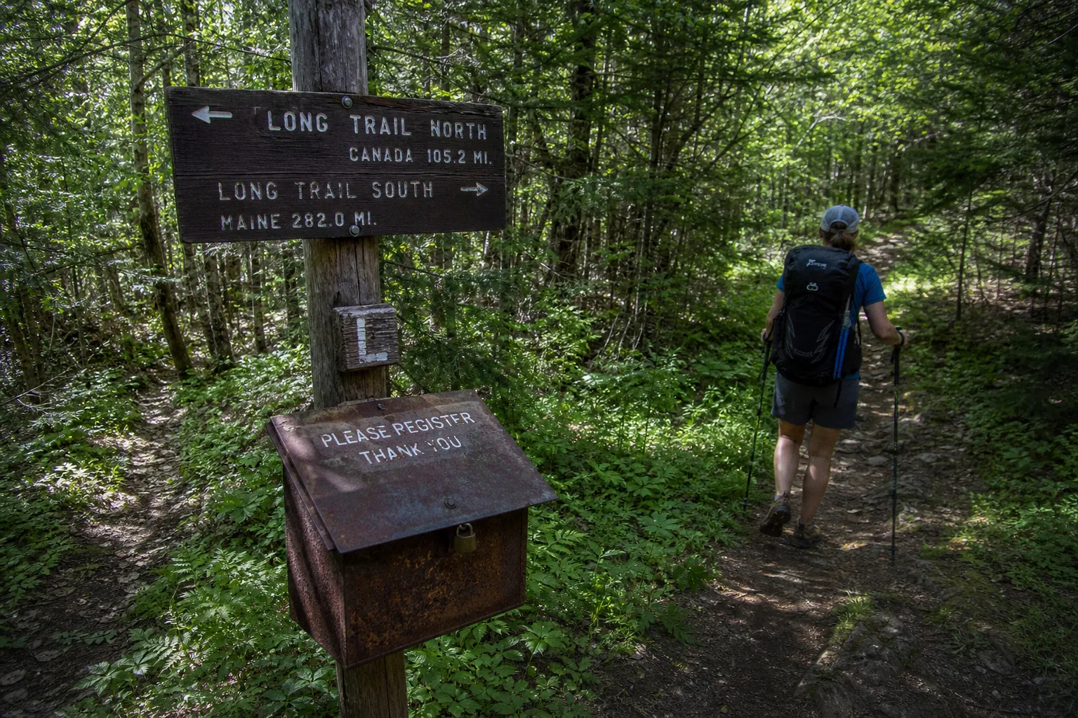
| Long Trail, Vermont | 272 miles | No hiking permit; some Green Mountain Club shelters/campsites typically charge $5 per night | Mud, roots, humidity, steep short climbs, slow travel |
| Ouachita Trail, Arkansas and Oklahoma | 223 miles | No permits or thru-hike registration required | Water planning, exposure, long stretches of quiet trail, seasonal heat |
| Benton MacKaye Trail, Georgia–Tennessee–North Carolina | Roughly 288–300 miles | Permit required only for its 93-mile Great Smoky Mountains National Park section; $4 per person per night | Remote stretches, variable maintenance, weather, fewer convenience services |
| Tuscarora Trail, Mid-Atlantic | About 250 miles | No permits required for most areas | Rugged tread, remoteness, isolation, routefinding discipline |
This is the correct way to evaluate alternatives to the PCT or any other high-demand route: not by asking whether they are famous enough, but by asking what kind of hiking they require.
A 250-mile trail that forces you to manage foot placement, water, resupply timing, and recovery is not “less.” It is simply not packaged for you.
Superior and Long Trail: two very different ways to earn your miles
The Superior Hiking Trail is one of the cleanest answers to permit fatigue. It runs more than 300 miles from Duluth toward the Canadian border. No hiking permit. No camping permit. That does not mean no responsibility. It means the energy goes into movement and field decisions instead of a lottery dashboard.
The SHT will not let you zone out. The North Shore terrain is a repeated cycle of climbs, drops, rock, roots, mud, and weather shifts. It is not high alpine in the western postcard sense, but the cumulative work is real. Short climbs done all day can grind the calves and load the knees just as effectively as a single long ascent.
Hikers coming from smoother, more graded trails often make the same mistake: they calculate mileage from the map and ignore the cost of constant terrain change. That is how cadence falls apart. They reach camp with their hip flexors locked, feet beaten up, and no usable energy left to eat properly.
On the Superior Hiking Trail, I would rather see a controlled daily average and strong camp execution than an inflated mileage target. Keep your pack tight to your back. Use trekking poles when the descents are greasy. Eat before the bonk. These are not glamorous rules. They work.
The Long Trail is another strong answer, but it is not the same animal. At 272 miles, it is short enough to fit a compact schedule and hard enough to punish anyone who thinks the Northeast is just rolling green terrain.
Vermont mud is not a minor inconvenience. Roots are not decorative. Humidity changes how your body cools, how fast your clothing dries, and how much salt you need to replace. The Long Trail has enough steep, rough movement to expose a weak kinetic chain fast—especially if you arrive with trail-running fitness but no loaded uphill strength.
Some Green Mountain Club-managed shelters and campsites charge a nominal $5 nightly fee. That is a far cleaner proposition than trying to win the right to walk a corridor months ahead of time. You still need to respect local rules, shelter capacity, and seasonal conditions. You simply are not gambling for the privilege of beginning.
What these two trails teach better than a lottery route
The Superior and Long Trail both force a useful correction: hiking performance is less about heroic single days than repeatable movement.
Build the ability to do this, day after day:
1. Climb under load without redlining. If every uphill spike turns into a max-effort breathless grind, your daily range collapses by midafternoon. Train with sustained loaded climbs or step-ups, not just flat-ground mileage.
2. Descend without braking yourself into knee pain. On roots, wet rock, and short steep drops, your quads act as brakes. Shorten your stride. Keep the knee tracking over the foot. Do not reach downhill with a locked leg and let your joints absorb the hit.
3. Protect your feet before they become the itinerary. Wet socks, wrinkled insoles, loose heel lock, and oversized daily targets can shred a trip in two days. Stop at the first hot spot. Dry what you can. Adjust lacing before the blister becomes a wound.
4. Manage your camp like a recovery station. Eat quickly, insulate early, sort tomorrow’s water, and get horizontal. Long-distance hiking rewards boring competence. Every wasted minute at camp steals from recovery.
That is the work. There is no lottery for it.
The Benton MacKaye and Tuscarora are better if you want fewer spectators
The Benton MacKaye Trail is the route I point to when someone says they want an Appalachian experience without walking inside the Appalachian Trail’s social current.
Depending on how it is measured, the BMT runs roughly 287.6 to 300 miles through Georgia, Tennessee, and North Carolina. It shares some of the broader southern Appalachian character—forest, ridges, steep terrain, weather volatility—but it does not carry the same continuous human conveyor belt.
There is one administrative exception worth understanding: the 93-mile segment that passes through Great Smoky Mountains National Park requires a permit, with a backcountry reservation fee of $4 per person per night. That is not “permit-free.” Pretending otherwise is how hikers show up misinformed and create problems for rangers and themselves. But outside that section, the trail offers considerably less paperwork than a fully quota-bound marquee route.
The BMT asks for attention. Trail maintenance can vary. Resupply is not always spoon-fed. Remote does not mean unmanageable; it means your plan needs margin. A missed turn, soaked insulation layer, or poorly timed food carry costs more when you are not within easy reach of a busy trail town.
The Tuscarora Trail is even more direct in its refusal to entertain you. Around 250 miles through Virginia, West Virginia, Maryland, and Pennsylvania, it is rugged, quiet, and remote compared with the AT. Most of its route does not require permits.
That quiet is valuable. It also removes the safety net of constant traffic.
You need to navigate without assuming another hiker will appear in ten minutes. You need to carry enough water when sources are uncertain. You need a bail plan that exists on paper before your ankle rolls, not after. And you need to be honest about your ability to travel through rough country when tired.
Solitude is not a product feature. It is a responsibility multiplier.
That is why I prefer these trails for hikers ready to graduate from crowd-supported backpacking. Not because crowds are bad. Because self-reliance is a muscle, and it does not grow while somebody else handles every logistical problem for you.
The Ouachita Trail proves that long distance does not require famous mountains
The Ouachita Trail runs 223 miles across Arkansas and Oklahoma, with no permits or registrations required for a thru-hike. It is a useful antidote to the idea that a major trail must be in a national park, above treeline, or constantly fed into your algorithm.
The Ouachitas bring a different set of demands. Heat can be punishing. Water planning matters. Long ridges and forested stretches can become psychologically repetitive if you need a new dramatic payoff every hour. Good. Learn to hike without being entertained.
That sounds harsh, but it is useful training for any serious backpacking route. The ability to maintain pace when the trail is not giving you a cinematic reward is what gets you through the hard middle of a long hike.
There is also a practical benefit: routes like the Ouachita Trail let hikers build long-distance systems without burning a huge amount of money or vacation flexibility. You can test your footwear, food strategy, pack fit, sleep system, and daily mileage expectations on a route that does not require winning a seasonal sweepstakes.
That test has value. A lot of people discover that their “dream” of a 2,000-mile trail is really a dream of buying gear and posting a start photo. A 200- or 300-mile regional route strips that fantasy down to the useful question: can you move well under load for ten to twenty days?
If the answer is no, fix it. Do not buy another titanium accessory.
“Permit-free” does not mean unmanaged
This needs to be said plainly because the phrase gets abused.
No permit requirement does not mean no rules. It does not mean you can camp anywhere, light fires whenever you want, ignore local closures, stash food carelessly, or leave a trailhead looking like a gear swap meet.
Even trails with broadly open access can cross lands with different regulations. A route can include state forests, national forest parcels, private easements, wildlife areas, local parks, or a national park segment. The Benton MacKaye’s Smokies section is the obvious example, but the principle applies everywhere.
The Tahoe Rim Trail is another reminder. The full loop is roughly 170 to 171 miles, but thru-hikers need a specific permit for the Desolation Wilderness segment. Zone 46 has a quota of 10 spaces per night. That does not make the TRT a bad choice. It means you plan the restricted piece precisely rather than treating the whole route as a frictionless loop.
The same goes for shorter destination hiking. Goat Rocks Wilderness in Washington can use free self-issued permits, while White Pocket in Arizona has no permit requirement. Neither fact removes the need for route research, weather awareness, and leave-no-trace discipline.
Here is the planning standard I expect before calling any route an alternative:
- Map every management boundary. Do not assume rules remain unchanged from one ridge to the next.
- Know the water reality for your season. A blue line on a map is not a guarantee. Heat, drought, and seasonal flow can turn a casual carry into a problem.
- Build a resupply plan that survives delay. Carry enough food for a slow day, a missed pickup, or a bad-weather pause. Tight margins are not efficient; they are fragile.
- Identify exits before you need them. Road crossings, shuttle options, cell coverage gaps, and pickup points should be understood before departure.
- Match your pack to the route, not to internet trends. A lighter pack is good only if it still keeps you warm, dry, fed, and functional when conditions turn.
This is the part that separates an independent hike from a poorly supervised one.
The regional trail advantage is not just access
The real appeal of alternative long distance trails in the U.S. is not that they are easier to book. It is that they pull the sport back toward competence.
On a high-demand corridor, the permit itself can become the center of the trip. The itinerary is fixed. The dates are fixed. The daily camps may be fixed. People then force their bodies and judgment to obey the reservation. They hike through warning signs because the permit says Tuesday is campsite three. That is backward.
A regional route often gives you room to respond. You can take a shorter day when your Achilles starts tightening. You can wait out dangerous weather. You can move camp based on water, fatigue, or a better terrain decision. Flexibility is not laziness. In the backcountry, it is a safety tool.
There is another benefit: these trails distribute attention. The outdoor world does not need every capable hiker fighting for the same famous corridor while hundreds of miles of excellent footpath remain underused, underfunded, or invisible outside local communities.
That does not mean treating regional trails as overflow parking for rejected lottery applicants. Go there with respect. Learn the route’s history. Support the volunteer groups and local organizations that keep tread clear, bridges intact, and shelters standing. A trail does not maintain itself because a GPS track exists.
The strongest trail choice is not always the one with the hardest permit to get. It is the one that matches your fitness, your available time, your technical judgment, and your willingness to carry responsibility.
Stop chasing validation through scarcity. Pick a route. Train for it. Learn its rules. Then put your boots on the ground and do the miles.